18 February 2025
Power Metal Resources
PLC
("Power Metal" or the
"Company")
Fermi Exploration:
Acquisition of the Fortin River Project
Preliminary Geophysical
Results Indicate the Presence of a Significant Uranium
Target.
Power Metal Resources plc (AIM:POW,
OTCQB:POWMF), the London-listed exploration company with a global
project portfolio, is pleased to report the acquisition by mineral claim staking of the Fortin River
Uranium Project ("Fortin River " or the "Project"), and preliminary
results from a recent geophysical survey flown over the project.
Fortin River is located in northern Saskatchewan, Canada.
HIGHLIGHTS:
·
Preliminary geophysical data indicates the
potential presence of a 1.7 km wide meteor impact crater on the
Fortin River Project. Such impact craters are targets for
unconformity-related uranium mineralisation elsewhere in Northern
Saskatchewan, with over 62Mlb of uranium mined from a major uranium
deposit located within the nearby Carswell Crater.
·
The inferred impact crater was previously
unidentified, with no modern and very limited historical
exploration carried out in the area.
·
Fortin River was staked by direct mineral claim
staking undertaken by the Fermi Exploration technical team, through
the Mineral Administration Registry Saskatchewan ("MARS")
electronic registry system. Further information on the staking
process can be found in the 'Further Information' section
below.
Sean Wade, Chief Executive
Officer of Power Metal Resources PLC commented:
"This is a very exciting development in one of our more
recently staked projects and we very much look forward to
investigating it further and reporting back. Momentum is building
across the uranium project set and we are looking forward to a very
exciting few months ahead."
FURTHER INFORMATION
Acquisition
and Location of Fortin River
The mineral claims constituting the Fortin
River Project (Figure 1) were acquired directly through the
Mineral Administration Registry
Saskatchewan ("MARS") electronic registry system.
Where a previous claim owner is unable to
satisfy the claim maintenance requirements, that ground is reopened
to third-party staking at a set time each month. Claim area
'reopenings' are often highly competitive with many parties
attempting to acquire the newly available land.
The total cost of staking the 3,859 hectares
(38.59 km2) which make up the Fortin River Project was
CAD $2,220; the newly staked licences come with a two-year term
with no minimum spend requirement, which can then be extended for
subsequent years by minimum work expenditure of Canadian $57,885
per annum ($15/hectare).
The Project is located in northern
Saskatchewan, 12km to the south of the Athabasca Basin, and 35km to
the southeast of Fermi Exploration's Badger Lake
Project.

Figure 1 - Location of the Fortin River
Project
Survey
Details
Following the acquisition of Fortin River, and
in conjunction with Fermi Exploration's surveys elsewhere in the
area, Fermi commissioned a combined Xcite™ magnetic and
electromagnetic ("EM") survey to be conducted over the Project area
by Axiom Exploration Group of Saskatoon, Saskatchewan ("Axiom").
Following the initial analysis, Axiom has provided the survey data
to Fermi Exploration, with final data pending final
reprocessing.
The survey was designed to test conductive
features identified by a prior operator1,2. An
electromagnetic survey provides information on how conductive the
underlying geology is; such surveys are common in and around the
Athabasca Basin as the exploration efforts focus on conductive
zones, such as graphitic pelites3. However,
electromagnetic surveys can also show heavily fractured
rock.
The preliminary survey results show the
presence of a ring-shaped electromagnetic response with a 1.4 km
diameter in the Channel 10 to 25 Slices (interpreted to be from
shallow-medium depths - Figure 2A and Figure 2B). In Channel 30 to
35 Slices (interpreted to be from medium depths - Figure 2C), the
ring-shaped response is replaced by a central electromagnetic
feature, approximately 1.2km in diameter. Finally, there is no
significant electromagnetic response at the Channel 40 Slices
(interpreted to be from medium-deep depths - Figure 2D). Selected
Channel Slices are shown in Figure 2. "Channel Slices" refer to the
discrete measurement readings taken at different frequencies or
depths during the survey, higher Channel Slices represent greater
depths.
The magnetic data from the survey (Figure 3)
indicates a magnetic low with a diameter of approx. 1.2 km within
the centre of the electromagnetic feature. The remainder of the
survey area appears to correlate closely with the magnetic
properties of the surrounding geology, including the regional
fabric.
Based on the survey data, the ringed
electromagnetic feature and an electromagnetic response from the
centre of the feature, is considered by the Fermi Exploration
technical team to be consistent with impact craters observed
elsewhere on earth and in Northern Saskatchewan. Analogies include
the Carswell Crater, 140 km northwest of Fortin River, which is 18
km in diameter, and the Pasfield Lake Crater, which is 10 km wide,
and located 200 km to the northeast of Fortin River. Both the
Carswell and Pasfield Lake Craters are within the Athabasca Basin,
associated with mineralisation, and are largely buried under
sandstones.
The concentric electromagnetic high on the
Project suggests that the feature is unlikely to resemble other
ring-shaped or concentrically formed geological structures, such as
kimberlite pipes. Additionally, the termination of the EM anomaly
in the Channel 40 slice (Figure 2D) at depth indicates there is no
continuation of conductivity directly beneath the central
electromagnetic feature in Slices 30 to 35 depth. Thus, the feature
is not related to a carbonatite or deeply trending conductive
feature where there is a continuity with the surface structure and
depth. Therefore, the feature is interpreted to have been formed
through the impact of a small meteor, which is inferred to have
caused intense disruption and fracturing to a comparatively shallow
depth.
Prior to this survey, no meteor impact crater
was known in or around the Project area. If the interpretations
above are correct, this survey marks the discovery of a new meteor
impact crater.

Figure 2 - Preliminary Electromagnetic Results from the Fortin
River Project
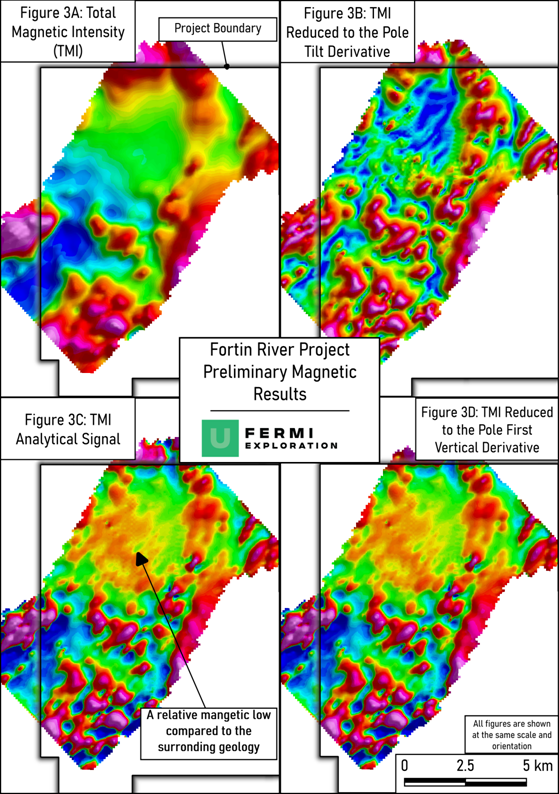
Figure 3 - Preliminary Magnetic Results from the Fortin River
Project
Implications
for Exploration
Meteor craters form when a high-velocity rocky
body (the meteorite) impacts with Earth, and is of sufficient size
to shatter the surrounding and underlying geology. This impact
creates a highly porous environment that enhances fluid flow. A
notable example is the Carswell Crater, located 140 km northwest of
the Fortin Lake Project. The former Cluff Lake uranium mine lies
within this crater, where a meteor impact 481.5 ± 0.8 Ma million
years ago4 played a key role in uranium deposit
formation by remobilising and reprecipitating uranium along newly
formed faults and fractures5,6. Over its 22-year
lifespan, the Cluff Lake mine produced more than 62 million pounds
of uranium7.
The Pasfield Lake Crater is subject to ongoing
uranium exploration by Terra 92 Uranium (ASX:T92). Historical
exploration of the feature has indicated anomalous helium > 230
times greater than the background, intense alteration overlying the
crater and surface uranium anomalies8.
The Fortin River Project is located 12.5 km
south of the current extent of the Athabasca Basin; and thus does
not have the Athabasca Sandstone cover present over the Carswell or
Pasfield Lake Craters. However, the Fortin River Project, remains
prospective for unconformity-related uranium deposits, as the basin
is understood to have extended significantly beyond its current
boundaries, and multiple unconformity-related discoveries (Arrow,
Triple R9, ACKIO10) have been made outside
the basin in recent years, within similar geology and
mineralisation styles to major deposits inside the
basin.
As such, the extension of the Athabasca Basin
outside of its current extent suggests the potential for
basement-hosted unconformity uranium deposits within the Fortin
River Project area. Additionally, the presence of the impact crater
greatly improves the prospectivity of the Project, as the impact
crater may have played a role in remobilising nearby
mineralisation, similar to the processes that formed the Cluff Lake
deposit.
Historical
Exploration of the Project
Fortin River has experienced minimal historical
and no recent exploration;
Initial geophysical survey work11 on
the north of the Project indicated a magnetic low in the vicinity
of the inferred impact crater and the contrasting relative magnetic
highs; at that time, the area of the Fortin River Project was not
considered of interest.
In 1979, the Project area was staked and
surveyed by Denison Mines, who completed an airborne
electromagnetic survey on southeast-northwest spaced flying lines,
and identified multiple closely spaced conductors in the centre of
the impact crater and inferred the conductive responses they
identified to result from folding or faulting1. A
further electromagnetic survey, also carried out by Denison Mines
supplemented this 1980 survey2, this time flying
north-south trending survey lines. The survey found an additional
conductive material, which was attributed to conductive sediments
at the base of the lake.
Since 1980, no work has been recorded from
Fortin Lake.
Proposed
Exploration and Next Steps
Upon receipt of the finalised data and report
from Axiom Exploration Ltd, geophysical inversions and further
analysis will be carried out to determine the location of fault
structures, which may be amicable for uranium
mineralisation.
Following this initial target generation, field
sampling and potentially further geophysical surveys may be planned
for the summer 2025 season to understand the prospectivity of the
project better.
GLOSSARY
Carbonatite - A type
of intrusive igneous rock that is largely composed of carbonate
minerals, such as calcite or dolomite. In mining, carbonatites are
important because they can host rare mineral deposits, including
rare earth elements, fluorite, and sometimes phosphate, which are
economically significant in mining.
Channels
(electromagnetic survey data) - In the context
of electromagnetic surveys, "channels" refer to the discrete
measurement readings taken at different frequencies or depths
during the survey. These channels represent different parts of the
electromagnetic signal that can provide insights into the
conductivity of subsurface materials, aiding in the identification
of mineral deposits.
Electromagnetic -
Refers to the use of electromagnetic fields to study subsurface
features. In mining exploration, electromagnetic (EM) methods are
commonly used to detect conductive materials (like sulphide ores)
by measuring how the subsurface responds to electromagnetic waves.
This can help identify mineralisation, such as base metals or
uranium.
Geophysical
Inversions - A technique used to interpret
geophysical data by creating models of the subsurface based on
measurements taken from the surface (such as magnetic,
electromagnetic, or seismic data). In mining and exploration,
geophysical inversions allow geologists to better understand the 3D
distribution of mineral deposits, faults, and other geological
features, aiding in target identification for drilling or mining
operations.
Graphic
Pelites - Fine-grained sedimentary rocks that
are rich in clay minerals. In the context of mining and
exploration, graphic pelites are often associated with sedimentary
basins and can be important for understanding the geological
history of an area, as well as being potential host rocks for
certain mineral deposits, particularly uranium in
unconformity-related deposits.
Kimberlite
Pipes - Vertical, carrot-shaped geological
formations made of volcanic rocks, which are typically associated
with diamond deposits. In exploration, kimberlite pipes are the
primary targets for diamond mining, as they often carry diamonds
from deep within the Earth's mantle to the surface. Identifying
these pipes is key to diamond exploration.
Magnetic - Pertains
to the use of magnetic fields to detect variations in subsurface
rocks, typically measured in magnetic surveys. In exploration,
magnetic surveys are commonly used to locate iron-rich minerals,
such as magnetite, and to map geological structures like faults or
volcanic intrusions that could host valuable deposits, such as gold
or copper
REFERENCES
1 Denison Mines Limited 1979, Kelic Montgrand Lakes Project,
Exploration Program, 74F08-0014
2 Denison Mines Limited, 1980, Airborne Electromagnetic Survey,
Kelic Montgrand Area, File No: 22033, 74F08-0015
3 Powell, B., Wood, G., Bzdel, L. Milkereit, B., 2007. Advances
in geophysical exploration for uranium deposits in the Athabasca
Basin. In Proceedings of Exploration (Vol. 7, pp.
771-790).
4 Alwmark,c., Bleeker, W., LeCheminant, A., Page, L., Scherstén,
A., 2017 An Early Ordovician 40Ar-39Ar
age for the ∼50 km
Carswell impact structure, Canada. GSA Bulletin; 129 (11-12): 1442-1449.
doi: https://doi.org/10.1130/B31666.1
5 Baudemont D., Fedorowich, J., 1996, Structural control of
uranium mineralization at the Dominique-Peter Deposit,
Saskatchewan, Canada, Economic Geology.
6 Leventhal J S, Grauch R I, Threlkeld, Lichte F E 1987 -
Unusual organic matter associated with Uranium from the Claude
deposit, Cluff Lake, Canada: in Econ.
Geol. v82 pp 1169-1176
7 Orano, 2020, Cluff lake Factsheet;
https://cdn.orano.group/canada/docs/librariesprovider13/canada/resources/factsheets/cluff-lake-factsheet-2020.pdf?sfvrsn=e9dd1034_9
8
https://t92.com.au/projects-v1/pasfield-lake/
9 Tschirhart, V., Potter, E. G., Powell, J. W., Roots, E. A.,
Craven, J. A., 2022, Deep Geological Controls on Formation of the
Highest‐Grade
Uranium Deposits in the World: Magnetotelluric Imaging of
Unconformity‐Related Systems From the Athabasca Basin, Canada, Geophysical
Research Letters, 10.1029/2022GL098208, 49, 15
10
https://baselode.com/news/baselode-reports-high-grade-uranium-assays-on-its-ackio-prospect/
11 Agarwal, R., G., 1970reprot on the Electromagnetic survey
Permit No 4. Lac La Ronge Area, Northern Saskatchewan, Northwood
Mining Ltd. 74F01-0008
QUALIFIED PERSON STATEMENT
The technical information contained
in this disclosure has been read and approved by Mr Nick O'Reilly
(MSc, DIC, MIMMM QMR, MAusIMM, FGS), who is a qualified geologist
and acts as the Qualified Person under the AIM Rules - Note for
Mining and Oil & Gas Companies. Mr O'Reilly is a Principal
consultant working for Mining Analyst Consulting Ltd which has been
retained by Power Metal Resources PLC to provide technical
support.
This announcement contains inside
information for the purposes of Article 7 of the Market Abuse
Regulation (EU) 596/2014 as it forms
part of UK domestic law by virtue of
the European Union (Withdrawal) Act 2018 ("MAR"), and is
disclosed in accordance with the Company's obligations under
Article 17 of MAR.
For further information please
visit https://www.powermetalresources.com/ or
contact:
|
Power Metal Resources plc
|
|
|
Sean Wade (Chief Executive
Officer)
|
+44 (0) 20 3778 1396
|
|
|
|
|
SP Angel Corporate Finance (Nomad
and Joint Broker)
|
|
|
Ewan Leggat/Jen Clarke
|
+44 (0) 20 3470 0470
|
|
|
|
|
SI Capital Limited (Joint
Broker)
|
|
|
Nick Emerson
|
+44 (0) 1483 413 500
|
|
|
|
|
First Equity Limited (Joint
Broker)
|
|
|
David Cockbill/Jason
Robertson
BlytheRay (PR Advisors)
Tim Blythe/Megan Ray
|
+44 (0) 20 7330 1883
+44 (0) 20 7138 3204
|
NOTES TO EDITORS
Power Metal Resources plc -
Background
Power Metal Resources
plc (LON:POW) is an AIM listed metals exploration company
which finances and manages global resource projects and is seeking
large scale metal discoveries.
The Company has a principal focus on
opportunities offering district scale potential across a global
portfolio including precious, base and strategic metal exploration
in North America, Africa and Australia.
Project interests range from
early-stage greenfield exploration to later-stage prospects
currently subject to drill programmes.
Power Metal will develop projects
internally or through strategic joint ventures until a project
becomes ready for disposal through outright sale or separate
listing on a recognised stock exchange thereby crystallising the
value generated from our internal exploration and development
work.
Value generated through disposals
will be deployed internally to drive the Company's growth or may be
returned to shareholders through share buy backs, dividends or
in-specie